Click here for my Anza Borrego CA '06, M21 Day 1 map.
Click here for my Anza Borrego CA '06, Sprint map.
Click here for my Anza Borrego CA '06, M21 Day 2 map.
Click here for my Anza Borrego CA '06, Maze (Badlands) O map.
This terrain is desert terrain, and there are no trees.
"White" means rough open or badlands.
First race of the season -- first control of first day, and
I nearly kill myself, falling into a gully head-first, and
my legs flipping all the way over. Head hit the ground right
near a big rock. Only lasting injury seems to be a sprained
wrist. They told me it wasn't broken, but it hurts like hell
sometimes. All I was thinking about was could I have been
hurt really bad, and why am I doing this. My concentration
wasn't there, and the terrain demanded such. I had a terrible
run.
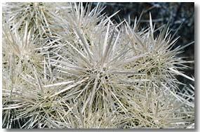
 Compounding my troubles, I got a cholla cactus embedded in my
leg, and I couldn't get it out, and I couldn't run without
waddling to avoid the pain. It took EMT a couple of tries to
pull the thing out with pliers. I don't consider myself a
wimp, but I screamed during this process. Fortunately, I
think they got it all. Wear gaiters next time.
Despite my injury problems, I thought the terrain was
beautiful, and the course setting decent. The badlands-like
terrain (the areas mapped with the impassable cliffs and
earth banks) was interesting and unique, and the more
subtle contour features out in the flatter desert were
also cool. The veg consisted of the aforementioned cholla,
and sundry other desert flora scattered about, which, had I
been paying more attention to the meet notes, I probably
could identify. It was very scattered, and viz was excellent,
but there were no trees to help with perspective, and all
gullies looked pretty much the same, making relocation difficult.
One think that was interesting was that the runnability was
better on areas mapped with the stony ground symbol. The
footing was better than the otherwise sandy soil. The sand
(and runnability) was worst of all in the washes. The rocky
ground tended to be higher, so the trick was to run ridges
and hills or any raised ground where possible.
The cholla seemed avoidable except when trying to read the
map on the run. Dis-incentives to read the map are never good,
so this added an interesting dimension to the racing.
The map was decent (almost all salient information being
contour base from Sterling), but boulders were inexplicably
unmapped. Jeff W. told me the mapper only mapped boulders
that "moved from their original location". Impassable
cliffs vs passable were decently accurate -- tho this is
subjective -- they are certainly harder to negotiate with
a bad hand.
My pet peeve of the meet was lousy map printing and cheap
map cases. The sprint was fine in these regards, so why
couldn't the same technology be used for the ranking days?
You spend $400 travel dollars, are in a stunning setting
with unique, championship terrain, and decent course
setting -- why cheap out on the map production? On the
margin of effort for producing this meet, it can't be all
that much. This came up in sanctioning, and I was assured
it would be fine. I have no answer as to what to do about
this.
I would have also recommended an IOF middle in the badlands,
cutting the last part of the course, and adding that to day
2, to make an IOF long. I think 6K on the former, and about
15+K on the latter would have been neat.
Anyway, day 2 went much better, tho I was still sloppy
and with day 2 speed. I ran with Vlad from about #3 to
#11, tho was trying to make my own routes and navigation.
I got ahead on the way to #12, but boomed #13, and Vlad
beat me in. Day 2 was less badlands, and more rough
navigation, tho you still had to pay attention to the
gullies. I thought day 1 was more interesting, but day 2
was more fun as I was not fretting over whether I had a
broken arm, and the one cholla I picked up fell off on
its own accord.
The maze O followed on the afternoon of day 2, in a very
rugged and intense badlands. It was Western Mass rules
score O, with an expected winning distance of about 3K.
It took me a little over an hour to do the course, tho
I wasn't pushing it, and couldn't climb like I would have
been able to un-injured. I did have some troubles with
the navigation, tho, having difficulty getting in sync
with the mapping. I could write more, but I believe Spike
will be posting a video that describes the event much
better than I could.
Cholla photos courtesy desertusa.com